Pakistan’s Karakoram is not the kind of mountain range you casually squeeze into a long weekend. The valleys are enormous, glaciers replace ordinary footpaths, camps can sit above 4,000 meters, and some routes continue for days without reaching a permanent settlement.
Exploring Pakistan’s Karakoram through high-altitude trekking routes takes you into one of the most dramatic mountain environments on Earth.
Gilgit-Baltistan contains K2 at 8,611 meters, along with Broad Peak, Gasherbrum I and II, and hundreds of other major summits. The regional tourism authority describes the area as a meeting ground of the Karakoram, Himalaya, and Hindu Kush systems.
For experienced trekkers, the attraction goes far beyond reaching K2 Base Camp.
Routes across Baltoro, Gondogoro La, Biafo, Hispar, and the quieter valleys around Hushe offer glacier travel, high passes, wilderness camping, and long stretches where expedition logistics become part of the adventure.
Start With the Baltoro Glacier and K2 Base Camp
The Baltoro route is the classic introduction to serious Karakoram trekking.
Most journeys begin around Skardu before continuing through Shigar and toward Askole, the traditional roadhead for expeditions entering the upper Braldu Valley.
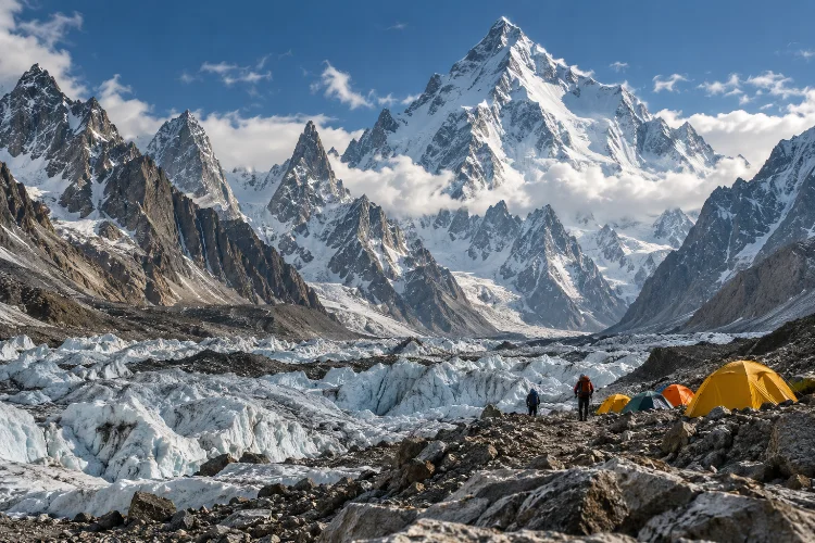
From there, trekkers move progressively onto the Baltoro Glacier toward camps such as Paiyu, Urdukas, and Goro before reaching Concordia.
Concordia is the geographic centerpiece.
From this huge glacial junction, several of the Karakoram’s most famous peaks dominate the horizon, including K2, Broad Peak, and the Gasherbrums. The Gilgit-Baltistan Tourism Department lists a typical K2 Base Camp journey at roughly 14–20 days depending on route and itinerary.
Unlike a lodge trek in Nepal, this is generally a camping expedition. Porters, kitchen staff, tents, food supplies, and waste management all become part of the logistics.
The difficulty comes as much from consecutive days on rough moraine as from altitude itself.
Extend the Trek Across Gondogoro La
For experienced mountaineering-oriented trekkers, returning the same way from Concordia is not the only option.
Gondogoro La connects the upper Baltoro system with the Hushe Valley, turning the K2 route into a spectacular traverse rather than an out-and-back journey.
The pass reaches approximately 5,585 meters. Gilgit-Baltistan’s official tourism information describes steep snow slopes reaching around 50 degrees, along with avalanche and rockfall hazards.
Fixed ropes and crampons may be necessary, and the route involves terrain classified well beyond ordinary hiking.
That distinction matters.
Gondogoro La should not be treated as simply “the harder version” of K2 Base Camp. Conditions can change rapidly, and whether a crossing is sensible depends on snow, weather, route fixing, and the judgment of experienced local teams.
When conditions cooperate, however, the descent into Hushe turns the trek into one of the Karakoram’s great point-to-point journeys.
Cross Biafo and Hispar for a True Glacier Expedition
The Biafo–Hispar traverse offers a different kind of challenge.
Rather than focusing on one famous mountain, the route links enormous glacier systems between Baltistan and the Nagar side of the Karakoram.
Official Gilgit-Baltistan tourism information describes Hispar Glacier as roughly 49 kilometers long and highlights the crossing from Biafo toward Snow Lake.
The journey reaches the vast high-altitude basin known as Snow Lake before crossing Hispar Pass at roughly 5,150 meters.
For long sections, your “trail” is glacier.
That means crevasses, broken ice, moraine, meltwater, route-finding, and campsite selection become constant considerations. Trekking poles and strong hiking fitness are not enough by themselves; the team needs glacier experience and appropriate safety systems.
The psychological challenge is also different from Baltoro. There is no famous base camp pulling you forward every day. The attraction is the crossing itself.
For trekkers who enjoy wilderness more than summit views, Biafo–Hispar can be even more rewarding.
Use Hushe Valley for Shorter but Serious Karakoram Routes
Not every advanced trek needs to last three weeks.
Hushe Valley gives access to a network of routes beneath dramatic granite and ice peaks including Masherbrum, Laila Peak, K6, and K7.
The regional tourism authority specifically identifies Gondogoro La, Masherbrum Base Camp, and the K6/K7 areas among its established trekking objectives.
These routes can work well for trekkers who want remote Karakoram terrain without committing to the full Baltoro expedition.
They are also useful for building experience.
A multi-day journey toward Masherbrum or Charakusa Valley introduces expedition camping, glacial terrain, and high camps while keeping the approach closer to established mountain communities.
Hushe itself gives the trip cultural depth. After days surrounded by moraine and ice, arriving among cultivated fields and Balti villages creates a dramatic contrast.
Understand That Glacier Travel Changes Everything
Karakoram trekking is often harder than the altitude number suggests.
Walking on moraine is slow. Rocks move underfoot, ice may be hidden beneath debris, and crevasses can complicate what appears on a map to be a straightforward valley.
That makes daily distances misleading.
A 12-kilometer glacier stage may consume far more energy than a 20-kilometer trail through ordinary alpine terrain.
Good boots, trekking poles, gloves, sun protection, and layered clothing are basic requirements. Depending on the route, crampons, harnesses, ropes, and technical equipment may also be necessary.
Strong navigation is important, but local knowledge is even more valuable. Glaciers move, streams change, and last year’s safe line may not be the best option this season.
This is one reason advanced Karakoram travel is typically organized with experienced local operators rather than attempted as unsupported backpacking.
Treat Acclimatization as Part of the Expedition
K2 Base Camp lies above 5,000 meters, and several major passes rise even higher.
You cannot compensate for altitude with fitness.
Well-designed itineraries gradually increase sleeping elevation and often include acclimatization or shorter days before the highest sections. Paiyu, Urdukas, Concordia, and similar camps are not just convenient stopping points – they help regulate how quickly the body gains altitude.
Symptoms such as persistent headache, nausea, severe fatigue, poor coordination, or breathing difficulty should never be dismissed because the itinerary says you have to reach the next camp.
Descending may be the correct decision.
Extra days also matter. Weather can block passes, roads to trailheads can be interrupted, and teams may need to alter camping locations.
Advanced trekking requires enough schedule flexibility to respond intelligently instead of forcing the plan.
Plan Permits Before Booking the Expedition
Permits are a major difference between Karakoram trekking and casual hiking elsewhere in Pakistan.
Pakistan Tourism Development Corporation guidance distinguishes between open and restricted trekking areas. Foreign travelers entering restricted trekking zones must apply under the appropriate visa category, and the permit process is handled with a licensed Pakistani tour operator.
Gilgit-Baltistan’s tourism authority likewise requires documents such as passport copies, route maps, operator information, insurance, and relevant fee receipts for regulated trekking and mountaineering applications.
Do not leave this until arrival.
Routes around Baltoro and other sensitive border areas require more administration than a normal tourist visit.
Using a licensed operator also makes porter arrangements, environmental fees, transport, and local coordination much easier. The tourism department maintains an official directory of registered operators.
Permit preperation is not glamorous, but it is part of Karakoram expedition planning.
Choose the Trekking Season Carefully
Summer is the main high-altitude trekking window.
The Gilgit-Baltistan Tourism Department lists roughly June through September as the general season for K2-area trekking. Outside that window, snow, cold, and access problems can make already serious routes significantly harder.
Even midsummer does not guarantee stable weather.
Glacial valleys create their own conditions, and storms can arrive quickly at altitude. Rockfall also becomes more relevant as temperatures fluctuate during the day.
Early starts are often useful, especially when crossing glaciers, snow slopes, or exposed passes.
Your clothing system should work across hot valley afternoons and freezing camps. Carrying lightweight equipment is helpful, but not if reducing weight leaves you without adequate insulation.
The Karakoram punishes optimistic packing.
Build the Trip Around Skardu
For Baltistan treks, Skardu is the practical expedition hub.
The regional tourism authority describes it as the base for routes toward K2, with onward travel continuing through Shigar and Askole.
Do not plan to arrive and immediately start walking.
Use at least a day to organize supplies, meet the trekking team, confirm permits, check equipment, and absorb any transport delays. Another spare day after the trek is equally valuable.
Long mountain trips rarely finish exactly as predicted.
Skardu also provides a useful psychological transition. Before the expedition, it is where urban travel turns into wilderness logistics. Afterwards, it is where a shower, proper bed, and simple restaurant meal can suddenly feel extraordinary.
Good accomodation planning here is less about luxury than recovery.
Leave Room for the Karakoram to Change Your Plan
A rigid itinerary is one of the least useful things you can bring into these mountains.
Road conditions, flooding, glacial movement, snow, and storms can all affect access. Gilgit-Baltistan’s current tourism portal regularly publishes travel advisories, including temporary road closures after flood damage.
That is why buffer days matter.
A two- or three-day margin can make the difference between calmly waiting for safer conditions and making poor decisions because of an international flight.
Satellite communication or another dependable emergency system can also be valuable on remote expeditions.
You are entering terrain where normal phone coverage should never be assumed.
Advanced Karakoram trekking is not about controlling every variable. It is about having enough experience, equipment, time, and local support to adapt when the mountains refuse to follow your schedule.
Exploring Pakistan’s Karakoram through high-altitude trekking routes reveals mountain travel on an expedition scale.
Baltoro and K2 Base Camp provide the iconic introduction, Gondogoro La adds a serious technical crossing, Biafo-Hispar turns glacier travel into the main objective, and Hushe opens quieter routes beneath some of the range’s most striking peaks.
These journeys require more than fitness. Acclimatization, permits, glacier awareness, experienced local support, weather margins, and realistic preperation all matter.
Choose the route that matches your actual mountain experience rather than the most impressive name on the map. Then give yourself enough time to travel it properly. In the Karakoram, the spaces between the famous peaks are often the most unforgettable part of the journey.